
Look Up Clark County Neighbors
The strongest block search begins with geometry, not a name. Clark County MapsOnline can locate a parcel and show the parcels beside it. The Property Information Center adds property-account context. The county neighborhood directory connects an address to an association boundary, while historic directories may identify same-street listings for a given year. Each source proves a different relationship.
| Clark County source | Block-level result | How to reach it |
|---|---|---|
| MapsOnline parcel block | Selected and adjoining parcels, with layer and map context | Find Parcel, then Identify nearby polygons |
| MapsOnline selection | A bounded set made by point, line, polygon, rectangle, or radius | Public viewer; some labels may have subscriber limits |
| Neighborhood Association Directory | County association boundary and page, not a member roster | Search by address, then zoom or click |
| Administrative layers | District, jurisdiction, and annexation context | MapsOnline Search tab and active layers |
| Historic street sections | Dated same-street directory entries | Library books, microfilm, or verified scans |
| Auditor parcel or legal search | Recorded-party chain for a selected parcel | Landmark index and instrument request |
A parcel record may identify a recorded owner or provide assessment and legal data. It does not list every occupant. A voter record has its own statutory rules and cannot establish a complete household. Use labels such as mapped adjacent parcel, recorded party, same-street directory entry, or shared neighborhood boundary instead of calling every result a current neighbor.
Historic street sections answer a different question. They can place printed names on the same block in one publication year, but omitted homes and missing volumes are common. Capture the directory title, year, page, exact address, and image or repository. Do not carry that dated association into the present.
Clark County Neighbor Map Tools
Open Clark County MapsOnline and use Find Parcel with a street address or tax account. The Identify tool can return a short report for the chosen polygon. Selection shapes include a point, line, polygon, rectangle, and radius with a unit and distance. Those tools define a block-sized set more accurately than a guessed list based on house numbers.
The official MapsOnline screen below is the source for locating a parcel before checking adjacent Clark County neighbors.
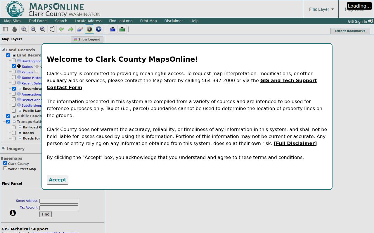
Save the map title, visible layers, scale, north arrow, selected object, and access date. A default map extent or parcel centroid should not be treated as proof of a person’s exact location.
PIC and MapsOnline expose related but distinct views. The county guide describes property, assessment, zoning, district, permit, tax, recorded-document, building, environmental, and map screens. Fields can vary by public access level. Record only what the live result displays, and follow a document link back to the office that keeps the official record.
Map Clark County Neighbor Parcels
Begin with one verified address and walk outward only as far as the question requires. Parcel edges can be irregular, and a road, rail line, creek, corner, or flag lot can change what next door means. Keep the selected parcel distinct from adjoining polygons throughout the workflow.
- Find the address in MapsOnline. Capture the selected parcel with scale and north arrow, then note its object ID or tax account.
- Identify every parcel that physically adjoins it. Use a radius or rectangle only when the goal is a broader, clearly bounded block.
- Check each parcel or address in the Property Information Center. Record the situs address, parcel ID, and jurisdiction, and avoid unnecessary mailing fields.
- If ownership history matters, search Landmark by parcel, legal description, or name. Describe each match as a recorded party until an instrument image supports more.
- For every home along a named road, use the Clark County street directory workflow instead of widening an immediate-neighbor search without limit.
Note: A map relationship is dated to the viewer and chosen layers; parcel changes or annexations can alter the later result.
Find Clark County Neighborhood Boundaries
The Clark County Neighborhood Association Directory offers Search by Address. Enter the address, zoom or click the dot or area, and open the neighborhood page. A result in county jurisdiction leads to county association information. An address inside Vancouver city limits is routed to the city neighborhood program.
The captured county directory below shows the address-search route used to place Clark County neighbors within a community boundary.
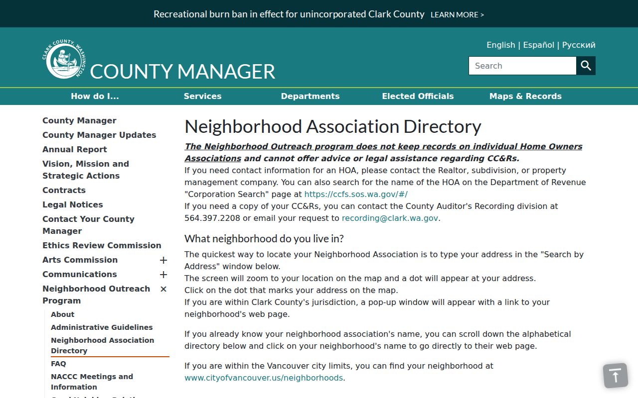
The boundary can supply a page, status, map, bylaws, board information, newsletter, or contact. It is not a list of people who live there. Association names and active or inactive status can change, so retain the access date.
Four Creeks Neighbor Example
Four Creeks shows how the community layer works without exposing a private roster. The official Clark County page identifies an active association dating from January 1999 and provides a contact and project information. Residence or business within a county association boundary makes participation automatic but voluntary and without dues under the county overview.
Four Creeks
Source: Clark County association page
Status: Active on the researched page
Contact: Andrew Cecka, fourcreeksna@gmail.com
County Neighborhood Program
Started: 1991
Outreach: Began August 1996
Records: Boundaries, bylaws, board rosters, maps, newsletters, and liaison information
Andresen appears as inactive in the sample inventory, while Chelatchie Prairie, Curtin Creek, East Fork Alliance, East Fork Hills Rural, Felida, Four Creeks, and Ridgefield-area groups illustrate the range of listed areas. Check the live directory before relying on any status.
Route Clark County Block Records
A Vancouver mailing address does not decide who keeps a permit or planning file. Clark County Community Development’s request process covers unincorporated Clark County. Use PIC and MapsOnline to capture the parcel jurisdiction, then route city-limit files to the relevant city clerk, planning office, permit office, police department, or court custodian.
Annexation can change that route. The county’s Van Mall North example took effect August 1, 2017, and the Annexation Tracker can connect an annexation ID to affected parcels. Save the city or county label, parcel PIN, neighborhood result, and annexation link. Postal ZIP, association boundary, parcel situs, and legal jurisdiction are separate layers.
If an existing county record is needed, use the GovQA public-records overview. A request can be submitted online and tracked through the portal; Washington law requires an initial response within five business days, which may be production, a link, an estimate, a clarification request, or a denial. Inspection itself has no fee.
Describe the record, department, address, parcel or permit number, and date range. Ask for electronic copies and a cost estimate before copying. For unincorporated property files, Community Development also accepts a portal request, email, phone, or mail. A city address must go to the city custodian instead.
Clark County Voter Block Limits
Washington voter records do not form a public household directory. VoteWA is an individual-facing match that asks for first name, last name, date of birth, and a recaptcha. A statewide voter-data request is a controlled route through the Secretary of State. Public fields under RCW 29A.08.710 can include name, address, political jurisdiction, gender, year of birth, voting record, registration date, and registration number, while the original form is confidential.
RCW 29A.08.740 restricts advertisements, offers, and solicitations based on voter-registration information. Address Confidentiality Program participants and other protected categories receive different handling. A registration result supports only that the person was registered in the stated jurisdiction at the record date. It does not prove present physical presence, ownership, household composition, or how anyone voted.
Compare Clark County Neighbor Sources
Official records and commercial neighbor tools answer different questions. An official source names its custodian, date, field, and correction route. A commercial result may combine old addresses and inferred relationships without exposing the source. Use the latter only as an unconfirmed clue and return to county or state records before making any claim.
| Source type | Useful for | Main limit |
|---|---|---|
| Clark GIS and parcel systems | Mapped parcels, jurisdiction, and property context | Ownership data does not equal occupancy |
| County association pages | Boundary, bylaws, board contacts, and civic news | No resident or member roster |
| Historic directories | Dated same-street names and addresses | Incomplete years and omitted households |
| Commercial compiled tools | Possible spelling or address leads | Unknown freshness, mixed sources, and inferred links |
For civic outreach, the association page is usually the better starting point because it publishes an official contact without exposing private households. For a parcel question, use GIS. For an older block, use a dated directory or newspaper scan. Matching the source to the question keeps the search narrow and easier to verify.
Protect Clark County Neighbors
No Clark County source supplies a complete current block-level address-and-name index or a public list of individual association members. Utility, delivery, full birth-date, original registration, and protected-address data are not made public merely because a parcel appears on a map. Renters and other household members may not appear in ownership records at all.
Publish only what the specific task needs. A general boundary map can explain jurisdiction without a precise geocode. Keep source dates, avoid merging people solely because they share an address, and provide the proper custodian route for a disputed field. Washington’s Address Confidentiality Program uses substitute-address handling for eligible participants, so a protected record should never be reverse engineered from other layers.
Lawful use. Clark County neighbor research is suited to civic participation, reconnection, property questions, and personal safety awareness. Never use it to watch, threaten, harass, or intimidate anyone.
When a result is uncertain, stop at the source label. “Mapped adjacent parcel” or “shared neighborhood boundary” is accurate. “Current neighbor” is not, unless a current, lawful source directly supports that conclusion.